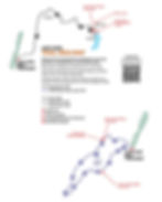
This is an easy and rewarding 2.4 mile loop trail that includes a visit to the Sherwood Natural Bridge, unique rock formations, and several outstanding overlooks of the Tom Pack Hollow and Crow Creek valleys, including one of the longest overlook views in the Park, where you can see nearly 17 miles into Franklin County. In the summer, this is a cool and shaded walk; when the leaves are off the trees, the views are even more spectacular.
Trail log with mileage:
0.0 Trail leaves the trailhead area on Old CCC Road, to the right of the trailhead kiosk.
0.1 Trail splits at this point; most hikers bear right, which leads to quicker views of the valleys below. Near the split, an ephemeral pond can be seen to the right.
0.2 The trail approaches the bluff-line, then roughly hugs it for the next mile.
0.5 Overlook, on right, with spectacular view of the upper Crow Creek valley and “Tunnel Hill,” where the Cowan Tunnel, one of the first major railroad tunnels in America (still in use today) was carved through the plateau in the 1840s. The white water tower you see is 12.5 miles northwest, in Decherd. Just past the overlook is the 25 foot long, 15 foot high Sherwood Natural Bridge, a sandstone arch carved by wind and water over the ages. The trail briefly splits, and hikers can either walk across the top of the “bridge”, or enjoy a view of it from the side.
1.0 On the left, the trail begins to flank a line of interesting sandstone formations as it edges its way out to the end of a long, narrow promontory of the plateau. Some of these were natural rock-houses that provided shelter to indigenous peoples when they climbed the plateau to hunt, hundreds or even thousands of years ago.
1.5 The trail rounds the tip of the promontory, and begins working its way through the rock formations on the southern flank.
2.2 Overlook to the south, with a “long view” of the rapidly widening Crow Creek Valley. In the distance, the railroad can be seen (and heard!) at the bottom of the valley. This is a busy rail line, with several trains each hour.
2.3 The trail peels away from the rock formations, and begins a leisurely traverse of the plateau’s “table land.”
2.4 The trail continues atop the plateau, until its return to the trail split, and back to the trailhead. All the forests you see here are second-growth, having been logged repeatedly between the 1850s and the late 1900s.


